This article first appeared on Today in Alternate History.
While many
different standards had been used to define state borders in the first
decades of the USA, the Territorial Amendment of 1847 was intended to
limit new states from being made that would be grossly imbalanced in
territory compared to the states already part of the union.
The amendment was proposed in 1846 and ratified the next year to preclude
any more distortions from either the hardcore New England or Plantation
South in how the rest of the continent would be organized.
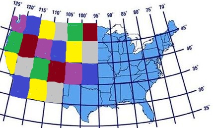
Often called the "Checkerboard Amendment," the act stipulated that from
the 49th parallel north and 95th longitude west, all territory in North
America belonging to the United States would be divided into squares
five lines of latitude by five degrees of longitude. The further from the equator, the closer together the lines of longitude become, so
five degrees was chosen as a reasonable standard for the area occupied
by the USA.
Because of the proposed amendment, Iowa reworked its borders to have 95
west as its western border and added a degree of territory north from
the nominal Minnesota Territory to make up for the loss. When Wisconsin
applied for statehood in 1848, the framers absorbed the remnant of the
pre-amendment MN Territory into the state as a northwest panhandle
giving the state a much longer Lake Superior shoreline.
Moving west from the 95 meridian line there were now six territories per
row across the great plains and rocky mountains. Because of the
amendment, the treaty settling the Mexican-American War specified that
the new border with Mexico would arbitrarily be set at the 29th parallel
to form four states per column crossing from the Rio Grande river
valley to the Pacific Ocean. Parts of Texas, Louisiana and Florida went
south of this point but all three had become states before the amendment
was ratified. For the sake of gaining more southern votes Texas
voluntarily ceded about 100 miles of its panhandle on the north and 80
miles of its territory that extended west of the 105 meridian longitude
line but, in exchange, received back the piece of New Mexico territory
east of the 105th meridian. Because of the angled coastline only three
new territories extended west of the new Texas border being the New
Mexico, Arizona and Baja California, with the latter being somewhat
triangular in shape. In all the rearrangement via grid created 21
territories in the west, which was somewhat less than the 30 existing
states once Wisconsin joined the union in 1848.
One provision of the amendment was that territories applying for
statehood were not required to declare the legality of slavery on a
statewide basis in order to qualify for admission, nor were they required
to maintain a status of slavery or free labor once they had become
states. So long as it was legal on the federal level, states could decide
individually whether the practice was economically and morally sound
for their geographic situation. Texas specifically was granted the right
to divide itself into four states based on the grid lines if they so
desired without further approval by Congress with the two northern
portions being delineated by the grid lines and the remaining portions
being the territory north of the Rio Grande border with Mexico but south
of the grid line.
Another provision modified the population requirement to be a large
enough population to have at least one representative if they were equally
apportioned after the decennial census. If the territory did not wish
to wait for the decennial federal census, they could use their own funds
to reimburse the Federal Census Bureau for an early count by federal employees. It was
felt necessary that the FCB do the counting to keep
territories from being tempted to inflate their population numbers to
gain earlier statehood.
With no further value politically in fighting the slavery issue because
of the amendment, the New England states ceased fighting the idea of a
Southern Pacific railroad on the grounds that it would make it possible
for southern slavery advocates to spread their beliefs more easily to
the Pacific Coast. Therefore in 1849 the Southern Pacific Act was passed
granting the builders of the railroad moving from Houston, Texas, to the
seasonal coastal village at Rocky Point on the north end of the Gulf of
California. This would allow rail traffic to a sea port on the west
coast giving the USA access to the many markets on the broad Pacific
ocean in the shortest time possible. A preliminary report filed by the
Army scouts during the Mexican-American War had already sketched out
the Southern Pacific route. With Federal support via land grants through
the New Mexico and Arizona territories and eastern money interests both
from northern banks and southern planters, work on the Transcontinental
Railroad/ Southern Pacific commenced on March 12, 1850.
The route for the Southern Pacific crosses 1,060 miles of rolling plains
and desert, much of which is occupied by native first peoples who saw the railroad as a threat and resist as best they are able. Despite their
efforts to halt work, the presence of US Cavalry allows the railroad crews to
advance at a mile a day laying track through the route. The final spike
of the initial railroad is driven on February 4, 1853, and supplies to
build a first-class port at Rocky Point begin arriving immediately with
most of the rail workers transitioning to general construction labor at
the same wages as before. The string-of-pearls arrangement of cavalry-company-sized forts built at each watering stop of the railroad house the
Army, and small towns spring up around them to supply the comforts every
soldier seeks in their off duty time.
By the Fourth of July, 1853, ships are arriving at Rocky Point, where they
load cotton or passengers before sailing to the West Coast or points
around the Pacific to sell their cargo. Rocky Point is a classic boom
town, and soon American cotton is found in as diverse a set of markets as
Australia in the South Pacific all the way to Russian Vladivostok in
the northwest Pacific. The American Navy is required to double in size
to secure the Pacific interests of the USA. Northern California becomes a
new state in 1854 with its capital San Francisco, ranging from 39 North
to 34 North and 120 west to the Pacific Ocean. The preponderance of the
gold strikes were in this area along with the most arable farmland and
forests. Oregon from 39 north to 44 north also starting at 120 west and
going to the Pacific also enters the Union that year, and Texas splits
off its two southern sections into the states of Jefferson and
Washington from the 29th parallel to the Rio Grande border with Mexico.
Via this division, Texas remains the largest US state by a small margin ,
but the slave economy states gain four senators to counterbalance North
California and Oregon in the federal Congress.
The entry of Kansas in 1861 is balanced by the entry of Arizona thanks
to the population that grew up around the port city of Rocky Point. The
1860 election resulted in the reelection of James Buchanan, who was seen
by most national politicians as a good man to keep the country running
on an even balance after his performance in office the prior four years. The Cotton South boomed with its new access to world trade, but, with
the exception of a few river valleys, the mostly desert area of Arizona
(State), New Mexico (Territory), and the more northerly Nevada &
Utah Territories aren't suitable for plantation agriculture. However, New
Mexico soon leads the way in the use of slave labor in manufacturing.
Ample coal deposits supply the fuel for steam powered looms turning
abundant raw Southern cotton into fine textiles for export across the
Pacific in competition with the New England looms, which concentrate
their skills more on northern wool as their main source of fiber.
Plantation owners in Alabama came around to the idea that labor saving
devices in growing cotton meant they could shift their now-surplus field
hands into working in the textile industry. By 1865, mechanical planters
and harvesters for cotton arrived on plantations, and
many slaves find themselves shifted to working
as industrial, rather than farm, labor. Instead of following the northern
model of concentrating industry in cities where "free labor" is often
desperate for employment and willing to work for low wages, the Cotton
South has their industry scattered far and wide over the plantation
system with railroads bringing down the cost of transporting the many small
suppliers' goods to market and keeping them competitive with the city
model followed in the North. By 1870, plantations across the South are
shifting to value-added export for the simple reason of profit. They can
earn double or triple the cash selling finished cloth instead of raw
cotton.
Provine's Addendum
While many nations in the world had outlawed slavery by the middle of the nineteenth century, the United States carried on with more than four million unpaid laborers, a number that would grow in the coming decades. The debate on slavery grew not only along lines of race and political ideology but also economics. Assurances that technology would eventually outpace the need for slavery proved incorrect as factories and cropland revitalized by scientific farming methods swelled the plantation coffers in the South, even keeping pace with the great wealth of bankers and industrialists in the North. Harriet Beecher Stowe, whose novels of plantation life such as Uncle Tom's Cabin and Dred: A Tale of the Great Dismal Swamp, continued writing with descriptions of life in the work-camps alongside mills and textile factories as well as the poorer farmers whose efforts without slave labor could not keep up and often found their farms in foreclosure.
Efforts to placate the working class included the Homestead Act, promising free land to those enterprising enough to develop it in the territories. This proved effective not only in absorbing surplus populations to limit unemployment but bolstering the population of future states like Pike, Cascadia, and Nebraska. In other areas, however, the plan backfired. The 160 acres proved to be much too small for cost-effective ranching in more arid regions like Cimarron and West Dakota where typical agriculture was out of the question. Eventually much of the settlers gave up and sold out to cattle barons.
Workers rights movements swept through the country, looking not only to end slavery but to establish safe and beneficial working conditions. Suggestions of secession are moot as the Cotton South's economy would be cut in half unless the entire line of states along the Southern Pacific railway joined them in leaving the Union. Instead, the wealthy lobbied Congress to maintain the status quo and literally battled strikers across the nation, whether coal miners in Virginia, harvesters in Arkansas, those seeking an eight-hour workday in Chicago, or railroad workers nationwide. Labor organizers reached across racial and regional lines, establishing camaraderie and using newspapers to dispel myths designed to keep workers fighting each other rather than the wealthy. Cycles of boycotts and strikes with improvements in conditions and pay finally led to the ends of slavery, child labor, and company towns. By the end of the First World War, the United States was one of most progressive nations in the world, its Congress balanced between two parties: Republican Socialists and the conservative Democrats.

No comments:
Post a Comment